|
With the recent tsunami in Indonesia that occurred on 23-Dec-2018 I’ve seen a lot of speculation on the state of the tsunami warning system and how it works. I thought I might address some of this on my blog as I spent about 4 years working at NOAA’s Pacific Marine Environmental Laboratory (PMEL) in the Engineering Division that designed the tsunami buoys and am intimately familiar with how they operate. I worked with many of the scientists and engineers that developed the first deep ocean moorings, which is a feet unto itself, and pioneered the tsunameter (they invented the word). The only true tsunami warning systems in place are based on technologies developed at PMEL); specifically the DART (Deep-ocean Assessment and Reporting of Tsunamis) buoys. The technology was spearheaded by Dr. Eddie Bernard, the current Director of PMEL, who began the project in the late 1970s. The system isn’t really a “warning system” that detects the tsunami and sets off an alarm; although the buoys can do that, that isn’t really their intended purpose. Instead they act as a large sensor network that supplies data to models for more accurate forecasting. In 2004 when the Indian Ocean Tsunami occurred there were only 6 DART buoys deployed in the Pacific; within 4-years the buoy network had expanded to 39 DART buoys and now includes buoys in the Pacific, Indian, and Atlantic Oceans. As you can see from the plot, buoys are now owned and operated by 8 different countries, but all are the same patented DART buoy developed at PMEL. 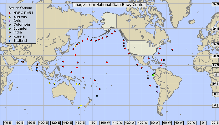 The earthquake would be first detected and registered by USGS and that information will be relayed to a Tsunami Warning Center (TWC). You can view near real-time information about detected earthquakes at the USGS website (Latest Earthquakes). That information will be entered into the models, which will indicate whether a tsunami could be generated and how it will likely propagate from the source. While that gives you a decent idea of whether a tsunami was generated and when it will arrive at various places on the other side of the ocean, it does not provide enough information to forecast the size of the tsunami or how many waves or how long an event it will be. This is where the DART buoys come into the picture as they can provide additional data to be fed into the models and refine the forecast of the tsunami. I won’t go into detail on how the buoys work here, but I will likely put together a post on that topic later. Suffice to say that they can detect a tsunami of just a few centimeters in a depth of water of over 5,000-m. The tsunami models ingest the wave height data from not only the DART buoys, but also shore water level stations (e.g. tide gauges), which refine the predictions for the wave height and event duration. With that the TWC can make better informed decisions on issuing evacuation notices or not. The above plot of DART buoys is pulled from the NOAA National Data Buoy Center (NDBC) website, where all the buoy data is available in near real-time (NDBC DART® Program). The International Oceanographic Commission (IOC) provides a worldwide plot of water level stations with real-time data on their website (SEA LEVEL STATION MONITORING FACILITY). Sadly, with the recent Indonesian tsunami there was no warning prior to the wave coming ashore and that means that many are looking for someone to blame. I’ve seen a lot of speculation on the age of the tsunami buoy network, vandalism of the buoys, and the inability to detect small waves (2-m in this case), but none of these factors is to blame and many are just blatantly incorrect. The fact is that this was a locally generated tsunami, which is regrettably very hard to detect and provide early warning for with tsunameters (e.g. DART buoys). A DART buoy would need to detect the tsunami, go into event mode, and transmit that data via satellite to the Tsunami Warning Center, who would then be able to issue a warning, but that warning would take time to disseminate and for an evacuation to begin. The volcanic event that likely generated this tsunami took place about 20-miles off the coast, with a tsunami being capable of traveling up to 500-mph, that’s about 2.5-minutes of warning if you detected the tsunami immediately.  The DART buoy array can detect tsunami wave heights on the order of centimeters, but this wave did not pass one on its way to the shoreline, as you can see in the close up NDBC buoy plot below. These buoys are meant for deep ocean deployment and for advanced warning/forecasting for distantly generated tsunamis. They are not intended, nor would they be effective, as near shore warning systems. 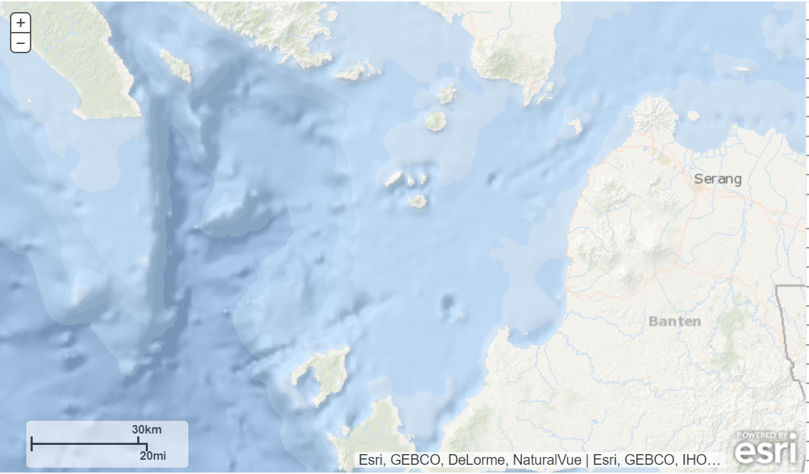 These sorts of local events are very difficult to detect and provide any advanced warning for, unless they are accompanied by a seismic event, which in essence is the early warning (i.e. you feel the earthquake and know to move to higher ground). In the case of a tsunami generated by a submarine landslide, there would be no warning. I don’t have all the facts/details, but regrettably, I don’t think there is an early warning system that could have prevented this.
Ultimately, providing the most accurate forecasting for tsunamis in a quick manner is what the system does, and that will save lives. Not only by telling authorities when to evacuate, but also by preventing unnecessary evacuations. You don’t want to be the little boy who cried wolf. With every unnecessary evacuation, people become less and less likely to heed future warnings.
0 Comments
Leave a Reply. |
AuthorBrent Pounds has over a decade of experience in the maritime industry and has been involved in recreations boating since he was a child. See the About section for more detailed information. Archives
October 2016
Categories
All
|
 RSS Feed