|
A while back I was asked on Quora, what my craziest boating experience was, and that got me thinking about my many adventures on the water. We once asked the Chief Mate on our training ship what the coolest thing he saw at sea was; he considered it for a few minutes before replying, “I don’t know…but I will say that is the dumbest thing I have ever been asked.” That is not the usual response and asking an open ended question like that to a sailor is a good way to get your ear talked off; after all, what sailor worth his salt doesn’t have his share of sea stories? I have many that come to mind and find it difficult to pick the craziest (a lot of crazy things happen at sea). Getting kicked off a pier by an Alaska State Ferry and having to pivot the ship in a basin about 30-ft wider than our ship was long springs to mind; sailing into a hurricane force storm in the Gulf of Alaska is probably the closest I’ve come to dying; a close call or two transiting a narrows in Alaska would also probably fit. However, these all involve a 231-ft ship and you asked about boating. I have a good number of stories from my time recreational boating, but doing hydrography in Alaska provided more than ample opportunity to get into crazy situations in small boats (I was not involved in the photo, but that is one of our survey launches and our very unofficial motto was, “we hit the rocks, so you don’t have to”). 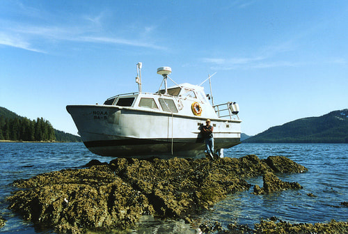 Never was there more likelihood of finding yourself in a predicament than when running shoreline verification. Essentially, we would wait until a negative tide window (when the tide was lower than charting datum of Mean Lower Low Water, or MLLW) and go out and run the 4-meter curve to verify the shoreline features (rocks, wrecks, reefs, ledges, etc.) that were acquired by photogrammetry or LIDAR. The coxswain would drive along the 4-m curve watching his fathometer and the hydrographer in charge would carefully verify all the features displayed on the computer screen and on the paper plot; annotating existing features, disproving erroneous features, and adding new features. I wasn’t aboard this boat, but they were disproving an offshore rock that they didn’t see by running a star pattern search over the position when they inadvertently proved the existence of the rock. The coxswain was probably running the star pattern a little faster than he should have and the boat came to an abrupt stop, ejecting the person that was serving as a bow lookout from the boat onto the rock, which was about 3-ft under the water surface. The coxswain immediately backed off the rock and the members of the boat crew (3 other people) began assessing the boat for damage; no one had noticed that the bow lookout had fallen off the boat until they heard him yelling “Man Overboard!” while standing on the rock. Luckily, no one was hurt, but he was very cold and wet. As for my personal experiences, I would have to say that it would have been getting high centered on a rock during shoreline verification. I was the Hydrographer in Charge (HIC for short) and I had three others in the boat, which was a 20-ft Monark aluminum hulled open workboat; a Survey technician and a coxswain in training driving under the tutelage of one of our more experienced coxswains. We were running shoreline outside of Sitka, AK and it was getting close to the end of the shoreline window (tide was rising to above MLLW). We had just finished going around Bamdoroshni Island and the coxswain pointed out an exposed rock offshore to the south. I checked the plot and sure enough it was there, previously charted and verified by photogrammetry. I checked it off and was about to say we had enough time to get around the next small island in the group when the coxswain asked me if we should verify that rock. I didn’t think it was really necessary, I was pretty sure it was charted correctly (the rock had a name, Tsaritsa Rock, and was marked with a buoy…people knew about it), but he asked if we could anyway for training purposed with the new coxswain. I didn’t see any harm in it and agreed. 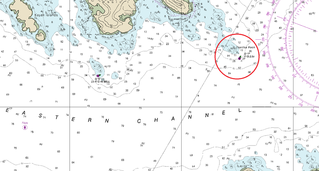 In order to verify a rock, or add a new rock, you need to get a Detached Position (DP) and the best way to do that is to put the bow as close to the feature as possible and then log a position on our survey computer. This was going to be a difficult feature to get a position on since it was fairly exposed to swell, but a pretty normal operation. So the coxswain talked the trainee through the approach and then let him take us in. I was watching the computer screen waiting for the coxswain to give me the signal that he was as close as he was comfortable getting so that I could mark the position. The next thing I knew, I felt a swell lifting us from the stern and surging us forward. It lifted us right up and set us down on top of the rock. The next few moments were crazy as the coxswain scrambled to take over from the trainee, who was panicked and had a look of utter shock on his face. We sat there for a few moments, high and dry on Tsaritsa Rock and I swear we teetered back and forth a bit, until the next swell came in, lifted us up off the rock, the trainee shoved the outboard into reverse, and we slid right back off the rock and into deep water. We all looked at each other like, “did that really just happen?”
It took a few minutes to check and make sure we weren’t taking on water and the engine and the propeller were undamaged. After figuring out everything was fine, we then debated whether we should radio the incident back to the ship or just keep it to ourselves. We really should have probably called the ship, but not wanting to get chewed out, we decided that we would just call it a very thorough rock verification. Tsaritsa Rock is charted as 0-fathoms 3-feet deep and I can attest to that accuracy.
2 Comments
Brent Pounds
1/7/2018 13:37:58
Glad you enjoyed this post; I may delve more into some of my sea stories in the future and maybe some more general nautical knowledge. Even though I've kind of wrapped up the Malibu and the houseboat, there will definitely be more protects to come. Leave a Reply. |
AuthorBrent Pounds has over a decade of experience in the maritime industry and has been involved in recreations boating since he was a child. See the About section for more detailed information. Archives
October 2016
Categories
All
|
 RSS Feed