the captain's blog
  • Home
  • About

THE Captain's Blog

The musings of a lightly-crusty, middle-aged, Salt.

A Nautical Library

8/1/2017

0 Comments

 
​Everyone is always asking me what books I would recommend they have on hand for the perfect nautical reference library…well, that’s not strictly true.  No one has ever actually asked me that question, but I think they should.  So I’m going to go ahead and answer it.  It’s my blog and I’ll do what I want!
Picture
​Obviously you aren’t going to stick a stack of books in a storage compartment on your bass boat (though that would be pretty cool), but on a houseboat or other large vessel you have the space to keep some useful references aboard.  I installed a bookshelf in the main salon on Serenity with this reference library in mind.  If you don’t have a houseboat of your own, you can always build your reference library at home; I have both.  Even the saltiest among us needs a little refresher once and a while, but what references are the most helpful when you’re out on your houseboat?
Picture
Picture
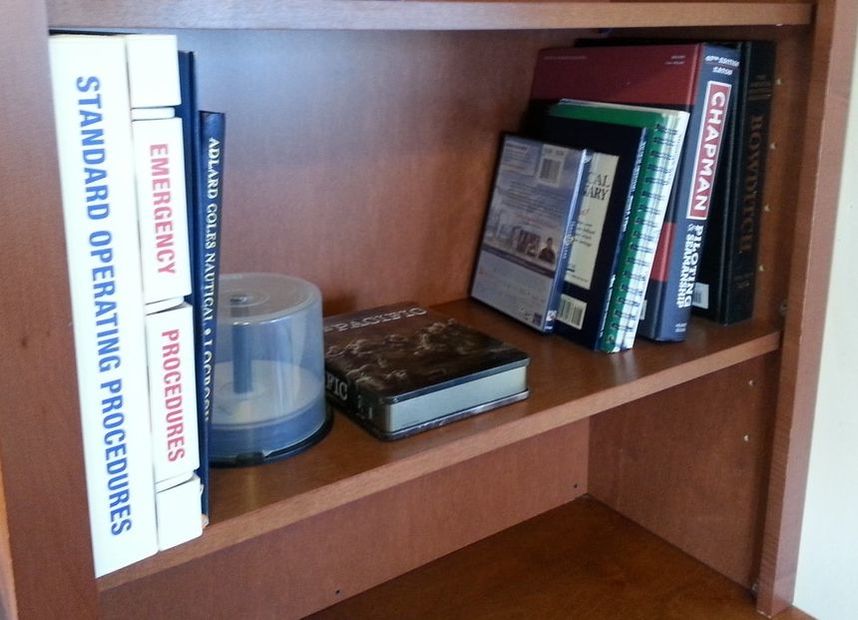
Since top ten lists seem to be so popular and I want to be popular too, below you will find my top ten recommendations for inclusion in your houseboat’s Reference Library.
  1. Rules of the Road. This is an absolute essential; it is required by law to be on the bridge of every commercial ship.  If professional mariners need to have this on hand for a quick reference on the navigation rules, it might be a good idea for you to have it as well.  While you should be pretty familiar with the basic navigation rules, there are some that are a little more obscure or seldom used.  For instance, you might see some lights that you’re unable to identify, like a vessel with an all-around flashing yellow light that flashes in groups of three (one flash every second for three seconds and then a rest period of three seconds).  If you have your Rules of the Road handy, you will discover that it’s a submarine navigating on the surface (one free internet for the first person that can tell me on what page that information is found in the Rules of the Road).  As a bonus you can quiz each other on lights and dayshapes, or on sound signals, or on give-way and stand-on vessels; it’s a great party game…or maybe that’s just me.  This information is contained in other reference books, but the Rules of the Road is the authoritative source and works well as a quick reference.
  2. Bowditch.  Technically, the name of this book is The American Practical Navigator, but everyone calls it Bowditch (the original author).  This book is a treasure trove of information on navigation, oceanography, and maritime weather.  It goes into greater detail than most would be interested in, but if you’re like me and want to get into the science behind why or how things work, this is the reference for you.
  3. Chapman.  Again, the name of this book is actually Chapman’s Piloting and Seamanship, but everyone refers to it by the original author and publisher’s name.  This book is considered “The Boater’s Bible” and for good reason.  It is probably my most frequently used reference and is, ironically, probably more practical than Bowditch, which can get mired in theory.  This reference runs the gambit from basic boating information, to seamanship and boat handling, to safety aboard a vessel, to vessel systems, to knot tying, to nautical traditions, to…well, if it’s not in this book, it’s probably not that important.
  4. Nautical Charts.  Nautical charts aren’t a reference book, you say?  Au Contraire (That’s French for on the contrary; all the popular people use French because it sounds fancy), there are Book Charts, and BookletCharts, and Chart Books; so there.  Now of those only the Book Charts are actual legal navigation charts and NOAA only produces a handful of them, so you’ve got me there, but I spent over 10-years making charts so they’re going to be on this list.  A paper chart of the area you’re cruising in is one of the most important reference items you can have.  I know that electronic charts and chart-plotters are all the rage now-a-days and I use one myself, but for me nothing will replace my paper navigational chart.  As a ship pilot I worked with once said, “the paperless bridge is a lot like the paperless bathroom; you’ll probably manage, but you may not like the result.”  Putting aside the fact that they are a necessary back-up for navigation if your electronics should fail (I always carry a paper chart even in my small boat), they provide a far superior overview of the area than you could ever get on a small screen.  In short, the paper chart allows you to plan ahead and is the basis for safe navigation.  Alas, for those of us navigating on Lake Powell there are no official navigational charts; the closest thing to an official chart would be the USGS topography maps from before the reservoir was filled, but I haven’t found those that useful.  The charts that I carry are the Fish-N-Map fishing charts, which prints one chart for the North end and one for the South end of the lake.  They are water resistant, have depth contours, include information on marinas, boat ramps, pump out facilities, navigational markers, and a host of other details.  As a side bonus for me, they also have a lot of good fishing information.  If I have the option though, I carry the official NOAA charts.
  5. Chart No. 1.  If you’re going to carry the charts, you should be able to read them.  A new edition (the 12th) of Chart No. 1 was released about 2-years ago that included all the Electronic Navigational Chart (ENC) symbology along with the traditional paper chart symbols.  Chart No. 1 is designed as a supplement to be used with official NOAA or NGA nautical charts and is set up as an index of all the symbols utilized on those charts.  Even after a decade of not only using these charts extensively, but also making them, I still find myself having to pull out Chart No. 1 from time to time to figure something out.  As with the Rules of the Road, other reference books will have this material covered in detail, but they don’t serve as the same quick reference that Chart No. 1 does.
  6. Coast Pilot or other Cruising Guide.  The Coast Pilot is published by NOAA as a supplement to the nautical chart in order to convey information that is difficult to portray on the chart itself.  They are printed in nine volumes divided into specific regions.  All the information is separated by chart number, so that you can quickly reference the Coast Pilot content with the chart you are using.  It has information on environmental factors of weather, descriptions of prominent coastal features and landmarks, information on small-craft facilities, specific hazard information, information on services like pilotage or towing, and specific regulations like designated anchorages or traffic separation schemes.  I could go on listing information contained in the Coast Pilot, but suffice to say that if you’ve not been to an area, the Coast Pilot should provide you all the information you need to navigate the area safely.  There are also a number of privately printed Cruising Guides that cover much the same information, but for me, I’d always go with the official government publication.  Unfortunately, Lake Powell is not covered in a Coast Pilot.  There are a couple cruising guides, but I’ve found them to focus more on hiking and regional attractions than on boating and I couldn’t comfortably recommend them.
  7. Ummm…are top six lists as popular as top ten lists?  Probably not, I bet it’s because of the lack of alliteration.  I guess I’ll never be popular, oh well.

Seriously, there are tons of other books and references that could be useful, but I think the above six are the real foundation of a good maritime reference library.  I’d be curious to know what your suggestions are for inclusion in a maritime reference library (not really, but it seems polite to ask); so go ahead and post your recommendations in the comment section.  Maybe we can get this up to a top ten list yet.​

Oh, oh, oh, I know…it’s a seminal six list…nope still not as good as a top ten, maybe it’s the “t’s” that make them so cool…  Oh well.  Until next time, here’s wishing you fair winds and following seas.


0 Comments


Leave a Reply.

    Author

    Brent Pounds has over a decade of experience in the maritime industry and has been involved in recreations boating since he was a child.  See the About section for more detailed information.

    Archives

    October 2016
    September 2016
    August 2016

    Categories

    All
    Boat Refit
    Lake Powell
    Lone Star Malibu
    Serenity Houseboat

    RSS Feed

Proudly powered by Weebly
Photos used under Creative Commons from NOAA's National Ocean Service, Farhill, GerryT, Rusty Clark ~ 100K Photos
  • Home
  • About